Research
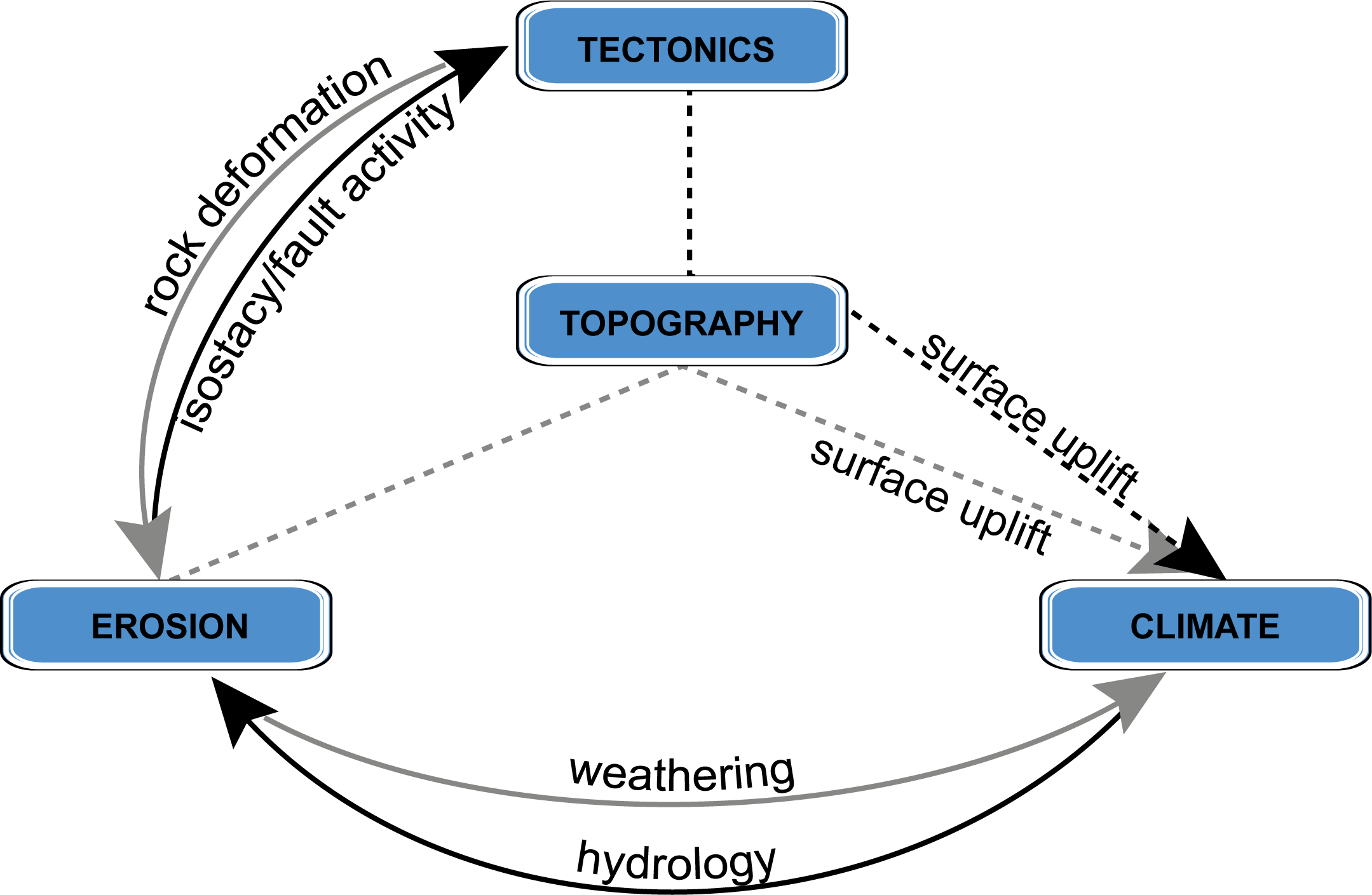
Our research connects the lithosphere to the atmosphere through the interactions of rivers, glaciers, volcanoes, faults, and precipitation. We rely on a broad set of tools including topographic analysis, geo- and thermochronology, field mapping, remotely sensed data analysis, geochemistry, thermo-kinematic modeling, landscape evolution modeling, and physical experiments.
Some of us work more in the lab, some in the field, others in the digital.
River dynamics
How do rivers adjust their width along their trace? How do river incision rates change with varying rainfall and what does this do to topographic relief? How much does rock type influence erosion rates and relief? These are just some of the questions that we are exploring regarding river dynamics.
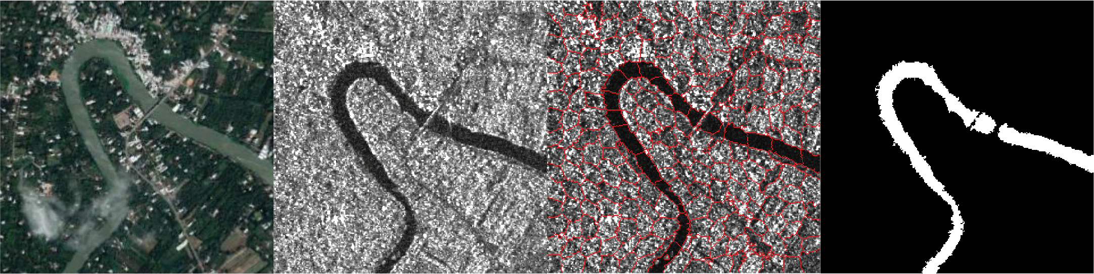
Using computer vision to find river channels in synthetic aperature radar (SAR) data.
From left to right - visible imagery, SAR imagery, segmented image using super pixels, final river mask.
Publications on river dynamics
- Pappas, O.A., Anantrasirichai, N., Achim, A.M and Adams, B.A (2020). River Planform Extraction From High-Resolution SAR Images via Generalized Gamma Distribution Superpixel Classification. IEEE Transactions on Geoscience and Remote Sensing. doi: 10.1109/TGRS.2020.3011209.
- Adams, B.A, Whipple, K.X., Forte, A.M., Heimsath, A.M., Hodges, K.V. (2020). Climate controls on erosion in tectionically active landscapes. Science Advances, 6, eaaz3166. doi: 10.1126/sciadv.aaz3166
Volcanic geomorphology
This research is still in its infancy, but is spinning up quickly. This Royal Society funded research revolves around the evolution of river and hillslope processes in volcanic landscapes. This approach has much to offer from a better understanding of the long-term impacts of volcanic processes on the growth of mountain ranges to the shorter- medium-term post eruption hazards.
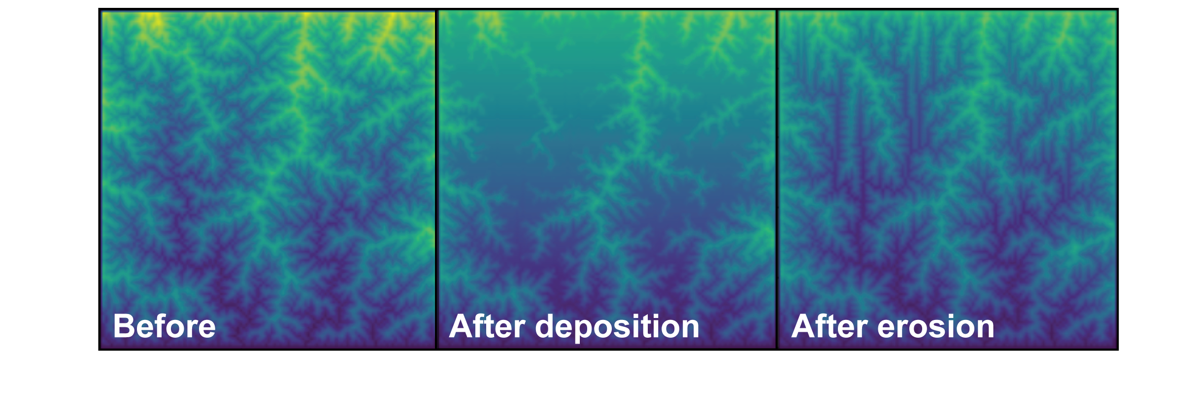
An example of how volcanic deposits can reorganize drainage networks. Output from a landscape evolution model.
Alpine glaciation
Glaciers have imprinted their preferred geometry on a landscape where erosion by fast-moving glaciers can outpace erosion by rivers and in some cases rock uplift. Therefore, modern topography integrates the effects of long-lived rock uplift, climate variation, and post-glacial landscape adjustment. Large low-gradient areas formed at elevations where alpine glaciers widened and deepened valleys. This implies a strong Plio-Pleistocene glacial climate control on the topography in some regions. However, the broad relief structure of the many ranges and the broad pattern in erosion rates appears to still record the regional rock uplift signal. Where have glaciers reset landscapes, and where have they just been window dressing?
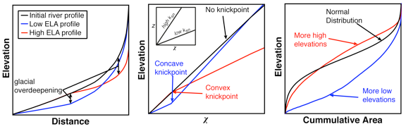
The hypsometry of glaciated landscapes is built on the foundation of channel relief. As such, slope-area analysis is as much an important tool for understanding relief controlling processes in mixed glacial/fluvial settings as in purely fluvial settings.
Publications on alpine glaciation
- Adams, B.A., and Ehlers, T.A. (2018). Tectonic controls of Holocene erosion in a glaciated orogen. Earth Surface Dynamics, 6, 595–610. doi.org/10.5194/esurf-6-595-2018
- Adams, B.A., and Ehlers, T.A. (2017). Deciphering topographic signals of glaciation and rock uplift in an active orogen: a case study from the Olympic Mountains, USA. Earth Surface Processes and Landforms, 42, 1680-1692. doi:10.1002/esp.4120
Landscape evolution
The present is the key to the past… and the future. By better understanding the fundamental processes that govern erosion, sedimentation, and fault activity re can reverse engineer and forward model the history of Earth’s surface. We use field observations, remote sensing data, and laboratory techniques (physical and chemical) to provide critical boundary conditions on our conceptual and numerical models. With these models we can look into the past and the future.
We use many lanscape evolution models - from the tried and true, to the new and experiemental, to better understand the influences of forcing factors such as rock uplift rate (see example here).
Publications on landscape evolution
- Adams, B.A., Whipple, K.X., Hodges, K.V., and Heimsath, A.M. (2016). In-situ development of high-elevation, low-relief landscapes via duplex deformation in the Eastern Himalayan hinterland, Bhutan. Journal of Geophysical Research Earth Surface, 121, 294–319. doi:10.1002/2015JF003508
- Cooper, F.J., Adams, B.A., Blundy, J.D., Farley, K.A., McKeon, R.E., and Ruggiero, A. (2016). Aridity-induced Miocene canyon incision in the Central Andes. Geology, 44, 675-678. doi:10.1130/G38254.1
- Adams, B.A., Hodges, K.V., Whipple K.X., Ehlers, T.A., van Soest, M.C., and Wartho, J. (2015). Constraints on the tectonic and landscape evolution of the Bhutan Himalaya from thermochronometry. Tectonics, 34, 1329-1347. doi:10.1002/2015TC003853
- Adams, B.A., Hodges, K.V., van Soest, M.C., and Whipple K.X. (2013). Evidence for Pliocene-Quaternary Normal Faulting in the Hinterland of the Bhutan Himalaya. Lithosphere, 5, 438-449. doi: 10.1130/L277.1
- Adams, B.A., Dietsch, C.D., Owen, L.A., Caffee, M.C., Spotila, J., and Haneberg, W.C. (2009). Exhumation and incision history of the Lahul Himalaya, northern India, based on (U–Th)/He thermochronometry and terrestrial cosmogenic nuclide methods. Geomorphology, 107, 285-299. doi: 10.1016/j.geomorph.2008.12.017